July 29, 2020
Planet Explorer:
New ✨
You can now analyze imagery (scenes) by ordering them to a hosted folder. This feature is still in “Beta” and you can try it out by enabling it in the Labs.
Improvements 🙌🏻
-
Timeline dropdowns
-
Measure tooltips
Bug Fixes 🐛
-
Weekly Basemaps labels
-
Collection of bug fixes when switching between Enhancement Imagery, NDVI, and browsing.
July 20 2020
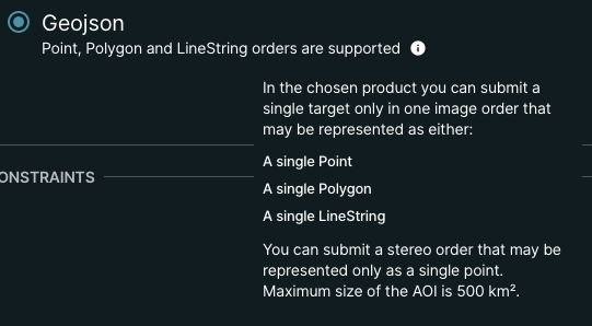
Question icon for GeoJSON informs the user about current capabilities of the chosen product:
July 17 2020
ArcGIS Add-In V1.2
New ✨
- Users can now select and download their entire basemap (they're no longer limited at 50 basemap quads)
- The "Create mosaic dataset" post basemap download is now an optional setting when selecting your basemap quads
Bug Fixes 🐛
- The basemap downloader tool now uses the default folder browser to prevent remove permissions errors when creating the mosaic dataset
- Extracting downloads from your orders panel no longer fails when un-zipping
July 14, 2020
Orders API supports a new "file_format" tool, which allows customers to convert their geoTIFFs to COGs (cloud-optimized geoTIFFs) and NITF 2.1 format to support more efficient workflows on the web. More information on this tool is available here: https://developers.planet.com/docs/orders/tools-reference/#file-format