PlanetScope, operated by Planet, is a constellation of approximately 130 satellites, able to image the entire land surface of the Earth every day (a daily collection capacity of 200 million km²/day). PlanetScope images are approximately 3 meters per pixel resolution.
Constellation and sensor overview
The PlanetScope satellite constellation consists of multiple launches ("flocks") of Dove satellites. On-orbit capacity is constantly improving in capability and quantity, with technology improvements deployed at a rapid pace. Each satellite is a CubeSat 3U form factor (10 cm by 10 cm by 30 cm).
Since our first launch in 2014, we have released three PlanetScope instrument types:
| Instrument Name | Instrument Id | Description |
|---|---|---|
| Dove Classic | PS2 |
Built with a telescope we call “PS2”, this instrument captures red, green, blue, and near infrared channels. It produces Scene products which are approximately 25.0 x 11.5 sq km. Earliest imagery available on July, 2014 to April 29, 2022. |
| Dove-R | PS2.SD |
Built with the same “PS2” telescope, but with updated Bayer pattern and pass-band filters, this instrument captures red, green, blue, and near infrared channels. It produces Scene products which are approximately 25.0 x 23.0 sq km. Earliest imagery available is on March, 2019 to April 22, 2022. |
| SuperDove | PSB.SD |
Built with a telescope we call “PSB” and the same filter response as PS2.SD instrument, this instrument captures red, green, blue, near infrared, as well as a new red edge, green I, coastal blue, and yellow channel. It produces Scene products which are approximately 32.5 x 19.6 sq km. Earliest imagery available is mid-March, 2020 to current monitoring. |
You can read a more detailed overview of our PlanetScope Constellation and Sensors here. For detailed technical information on PlanetScope images refer to PlanetScope Product Specification.
Imagery products
Item types
PlanetScope Products are available for search and download via Planet’s APIs, User Interfaces, and Integrations, in the form of Basic Scene and Ortho scene products, which are available through our platform as a set of Item Types and Asset Types.
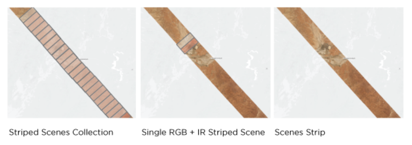
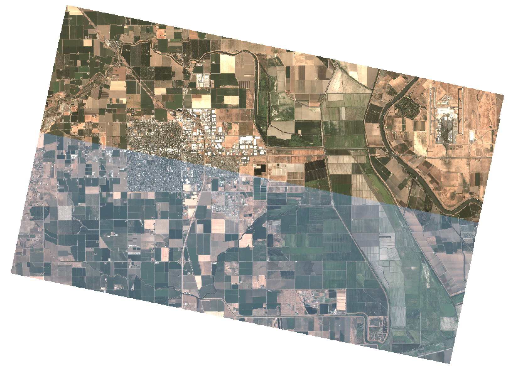
A PlanetScope Scene Product is an individual framed scene within a strip, captured by the satellite in its continuous line-scan of the Earth. Scenes within a strip are overlapping and not organized to any particular tiling grid system.
PlanetScope Scene products range from approximately 280 to 630 square kilometers in size, depending on which instrument type captured them. They are represented in the Planet Platform as PSScene item types. PSScene supports access to 8-Band imagery (RGB, NIR, Red Edge, Yellow, Green I, and Coastal Blue).
Asset types
PlanetScope Scene imagery products are available for download in the form of imagery assets. Multiple asset types are made available for Scene products, each with differences in radiometric processing and/or rectification. See PSScene Supported Assets for asset type availability.
Basic Analytic (basic_analytic) assets are non-orthorectified, calibrated, multispectral imagery products that have been corrected for sensor artifacts and transformed to Top of Atmosphere (at-sensor) radiance. These products are designed for data science and analytic applications, and for users who wish to geometrically correct the data themselves with the associated rational polynomial coefficients (RPCs) asset type.
Analytic (analytic) assets are orthorectified, calibrated, multispectral imagery products that have been corrected for sensor artifacts and terrain distortions, and transformed to Top of Atmosphere (at-sensor) radiance. These products are designed for data science and analytic applications which require imagery with accurate geolocation and cartographic projection.
Visual (visual) assets are orthorectified, color-corrected, RGB imagery products that are optimized for the human eye, providing images as they would look if viewed from the perspective of the satellite. These products are designed for simple and direct visual inspection, and can be used and ingested directly into a Geographic Information System or application.
Surface Reflectance (analytic_sr) assets are orthorectified and radiometrically corrected to ensure consistency across localized atmospheric conditions, and to minimize uncertainty in spectral response across time and location. These multispectral imagery products are designed for temporal analysis and monitoring applications, especially in agriculture and forestry sectors.
Note
Surface Reflectance asset types take longer to generate than our other PlanetScope products. They are typically available 8-12 hours after an item is published to our catalog.
You can find our complete Imagery Product Specification here.
Product naming
The name of each acquired PlanetScope image is designed to be unique and allow for easier recognition and sorting of the imagery. It includes the date and time of capture, as well as the ID of the satellite that captured it. The name of each downloaded image product is composed of the following elements:
PlanetScope Scene
<acquisition date>_<acquisition time>_<acquisition time seconds hundredths>_<satellite_id>_<productLevel>_<bandProduct>.<extension>
Example: 20200922_183720_11_106a_3B_AnalyticMS.tif
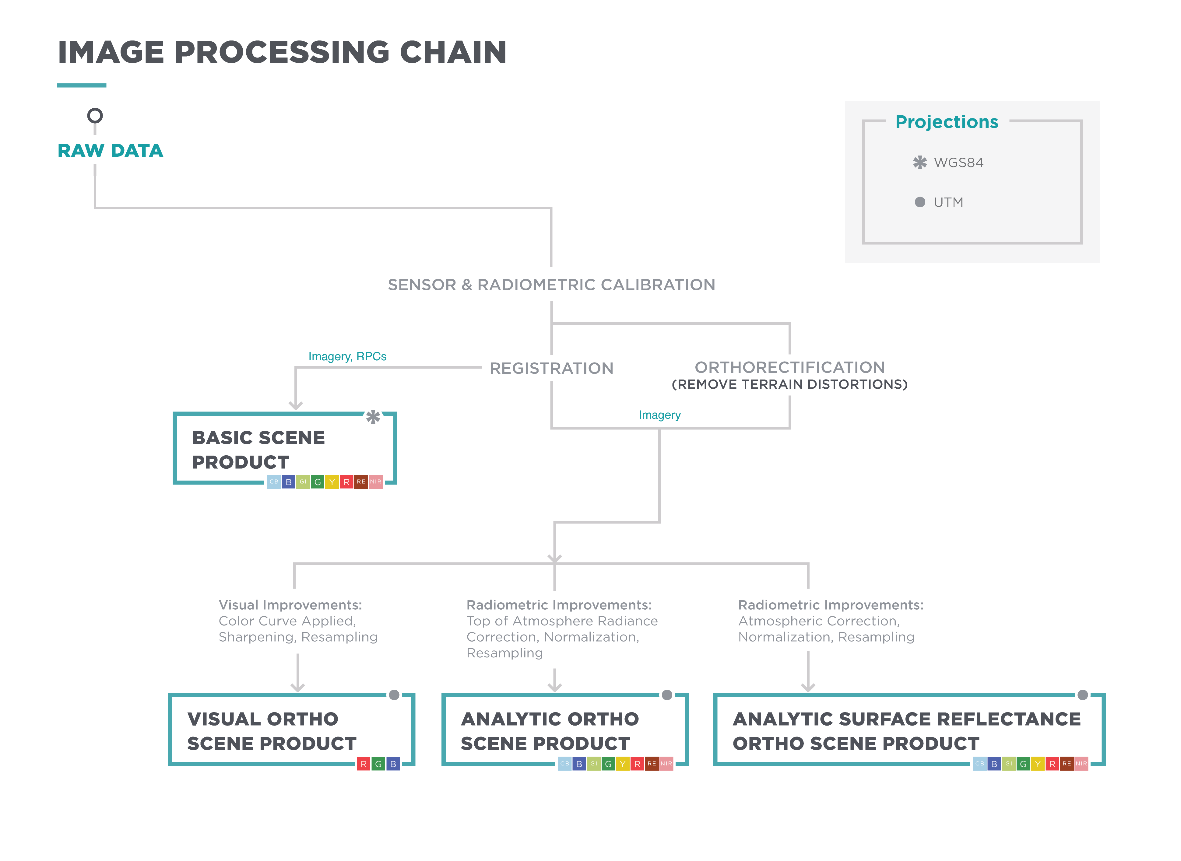
Processing
Several processing steps are applied to PlanetScope imagery to produce the set of data products available for download.
Click for full-size image
Sensor and radiometric calibration
Darkfield/Offset Correction: Corrects for sensor bias and dark noise. Master offset tables are created by averaging on-orbit darkfield collects across 5-10 degree temperature bins and applied to scenes during processing based on the CCD temperature at acquisition time.
Flat Field Correction: Flat fields are collected for each optical instrument prior to launch. These fields are used to correct image lighting and CCD element effects to match the optimal response area of the sensor. Flat fields are routinely updated on-orbit during the satellite lifetime.
Camera Acquisition Parameter Correction: Determines a common radiometric response for each image (regardless of exposure time, number of TDI stages, gain, camera temperature and other camera parameters).
Absolute Calibration: As a last step, the spatially and temporally adjusted datasets are transformed from digital number values into physical based radiance values (scaled to W/(m²strμm)*100). For additional technical detail, refer to On-Orbit Radiometric Calibration of the Planet Satellite Fleet.
Orthorectification
Removes terrain distortions. This process consists of two steps:
- The rectification tiedown process wherein tie points are identified across the source images and a collection of reference images (ALOS, NAIP, Landsat) and RPCs are generated.
- The actual orthorectification of the scenes using the RPCs, to remove terrain distortions. The terrain model used for the orthorectification process is derived from multiple sources (Intermap, NED, SRTM and other local elevation datasets) which are periodically updated. Snapshots of the elevation datasets used are archived (helps in identifying the DEM that was used for any given scene at any given point).
Visual product processing
Presents the imagery as natural color, optimized as seen by the human eye. This process consists of three steps:
- Nominalization - Sun angle correction, to account for differences in latitude and time of acquisition. This makes the imagery appear to look like it was acquired at the same sun angle by converting the exposure time to the nominal time (noon).
- Unsharp mask (sharpening filter) applied before the warp process.
- Custom color curve applied post warping.
Surface reflectance product processing
Removes atmospheric effects. This process consists of three steps:
- Top of Atmosphere (TOA) reflectance calculation using coefficients supplied with the at-sensor radiance product.
- Lookup table (LUT) generation using the 6SV2.1 radiative transfer code and MODIS near-real-time data inputs.
- Conversion of TOA reflectance to surface reflectance for all combinations of selected ranges of physical conditions and for each satellite sensor type using its individual spectral response as well as estimates of the state of the atmosphere.
You can find a detailed white paper on our Surface Reflectance Products here.
PlanetScope imagery collection versus publication
While the PlanetScope constellation collects imagery of nearly all the landmass on Earth at a daily cadence, imagery must pass all quality thresholds for publication in our catalog. There are a few common reasons for non-publication of imagery or for the publication of test quality imagery in lieu of standard imagery.
Starting on July 19, 2023 Planet will be publishing all unrectified PlanetScope images. For more information on what this means, read our Publishing All Unrectified PlanetScope Imagery knowledgebase article. Previously, these images were not published due to not meeting strict rectification rules. Majority of these images have heavy cloud cover which prevents our pipelines from rectifying imagery correctly and achieving ground lock. Unrectified imagery was only published in special circumstances but we made it global.
If you notice gaps in image publication in your area before July 19, 2023, it’s very likely due to clouds, as weather conditions vary tremendously region to region. If you see gaps after July 19, it’s very likely due to band misalignment, missing pixels, other image processing issues, or because there was no collection over the area.
Lack of ground lock
About 95% of the time lack of groundlock is due to clouds. However other conditions, such as extreme latitudes, topography and open water can also impact our ability to reference images to the ground. Non-groundlocked imagery only has approximate geo-location. We recommend only using imagery that has achieved groundlock to prevent user dis-orientation or analysis errors. All images that do not have ground lock use are classified in the image metadata as publishing_stage: preview.
Very occasionally a test quality image without groundlock will achieve groundlock and be re-categorized after 24-72 hours. However, it is more common that ground control points get refined post-publication. Normally this happens within the first 24 hours an image appears in our catalog.
Non-publication due to image quality
A small percentage of images collected cannot be fully processed due to anomalies in image capture, atmospheric conditions, or other factors. To maintain quality standards we do not publish anything that cannot be processed to a final composited image.
Image quality: standard vs test imagery
Planet’s data API provides metadata in regards to image quality. This falls into two categories: standard and test. The vast majority of published imagery falls into the standard category, meaning that it’s passed all Planet’s image quality metrics in the processing pipeline. To qualify for standard image quality an image must meet all of the following criteria:
- sun altitude greater than or equal to 10 degrees
- off nadir view angle less than 20 degrees
- saturated pixels fewer than 20%
- image has obtained at least 200 ground control points during rectification
- band alignment threshold (based on across-track registration residuals) of less than 0.3 pixels for all band combinations.
The remaining published imagery falls into the test category. The majority of test-quality images are categorized this way due to no lack of ground lock, or less than 199 ground control points, band alignment of less than 0.5 pixels, or a high volume of no signal pixels.
For use cases that require fine positional accuracy, we recommend using images that have ground_lock: true. Test images are usable images and are appropriate for most use cases.
You can find whether an image is standard or test quality within the scene metadata in Explorer.
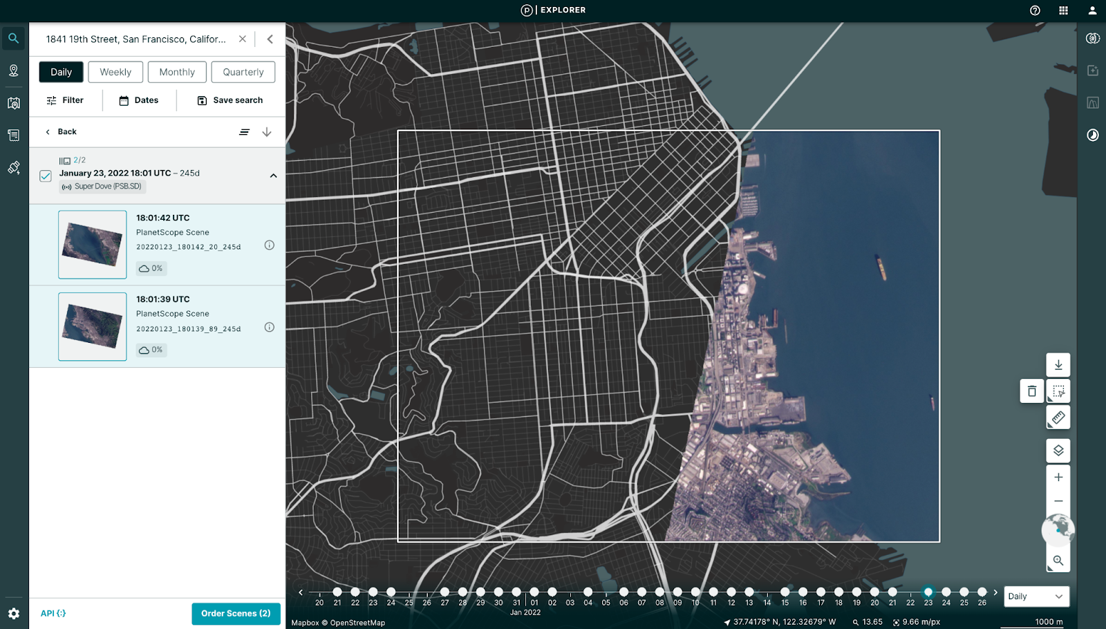 Access scene meta data via the info icon
![]() View scene meta data in the table on the left, look for “Quality category”
View scene meta data in the table on the left, look for “Quality category”
Rate this guide: