April 19, 2023
New ✨
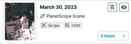
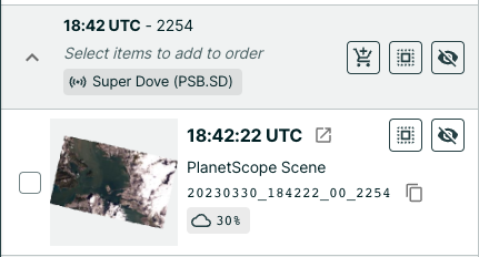
- It is now easier to preview and order imagery. When you search for imagery, you will see three new buttons. Click X items button to check out each satellite image from that date and make the best choice. Click the eye button to preview the imagery from that date on the map. Click the cart button to add the imagery to your order. You can select and de-select imagery from multiple dates. You can also lock the footprint of an image onto the map to get a better sense of coverage.
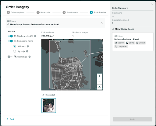
- When you place an order, there is a new option to composite images, which stitches them together. You will receive fewer files and consume less quota. Composite all will give you one file and composite by strip will provide the most consistency (spatial, spectral, environmental, etc). Take a look at the impact of each option on the map to get a sense of what you will receive.
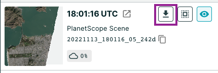
- You can now more easily use your Hosted Data in other tools and platforms. Download the Cloud Optimized GeoTIFF (COG) and pull it into other web applications at no extra cost.
Improvements 🙌🏻
- You can now select MGRS as a format in Settings, under the Coordinate System section. You can also easily copy MGRS coordinates out of Explorer to paste into other systems. The coordinates can be found in the bottom banner of the app. Please note: precision varies by the zoom level and resolution.
February 08, 2023
Improvements 🙌🏻
- It is now easier to select your time of interest in Explorer, especially for date ranges beyond two months. You can now enter your start and end date ranges as well as select them on the calendar.
- We have made improvements to Compare mode. You can now see the search field while in Compare mode. If you'd like to search for another location, you can do so faster now.
- If you try to place an order clipped to a complex geometry, the order will fail. We now include a fail safe in Explorer that disables the clipping option if your geometry is too complex. This way, you can place an order that will go through successfully.
- We have changed the defaults when you place an order. Harmonization will no longer be on by default; this tool is best applied if someone is ordering PlanetScope data from various constellations (for example, SuperDove and Dove-R); this situation does not apply to most people because SuperDoves provide full coverage. The clipping tool will remain on by default.
Bug Fixes 🐛
- Small AOIs will now show their area correctly up to 3 decimal places instead of 0 km2.
- We've fixed an issue that led to the application crashing when SkySat items were ordered as Hosted Data.
December 08, 2022
Improvements 🙌🏻
- The Import Dialog is updated to provide improved validation and assistance when a geometry needs to be simplified.
- If you upload a multi-feature file (multiple geometries in one file), all features display on the map. You can easily inspect your selections with a geo reference instead of a thumbnail. You can choose to select or deselect all.
- If your geometry contains more than 500 vertices or if it contains self intersecting points, you are presented with simplified alternatives. These alternatives are supported when selected.
- Measurements no longer display as abbreviating measurements. For example, 1,500 km2 instead of 1.5k km2.
Bug Fixes 🐛
- This release fixed an issue when moving Hosted Data items to folders. Now only selected data is moved.
- There were issues reordering past orders that were not clipped. Now you can now reorder without issues.
November 16, 2022
Improvements 🙌🏻
- You can now clip Hosted Data orders if you have clipping permissions.
- You can re-order a previous order from the Orders tab.
- When searching for a specific address, a pin marker indicates a single point at the searched location.
Bug Fixes 🐛
- When in compare mode, compare cards did not correctly display the timestamp.
- Searching for locations could result in a default selection of the first item in the result list instead of the desired selection from the list.