August 24, 2022
Improvements 🙌🏻
We've made some updates to improve our location search. We heard your feedback that it was challenging to find natural features, such as volcanos, and this update should make that easier.
Bug Fixes 🐛
We fixed an issue that was causing the application to crash when uploading large files (4MB+)
July 7, 2022
Bug Fixes 🐛
When attempting to edit date ranges, you may have been unable to select the most recent date. We've fixed issues in our date picker so the most recent date available can now be selected.
We've also reverted the default date range from one week back to three months.
April 26, 2022
New ✨
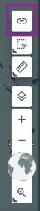
We have a new way for you to share your Explorer session with others. The days of long URLs are over! You will notice that we no longer update the URL as you take different actions in the application or as data loads. We have added a way to generate a share link via a new "Share Session" button (see screenshot), this link contains the same information as our "old" long URLs but in a more compact form.
Improvements 🙌🏻
Measurement tools now use geodesic calculations to better measure areas near the equator.