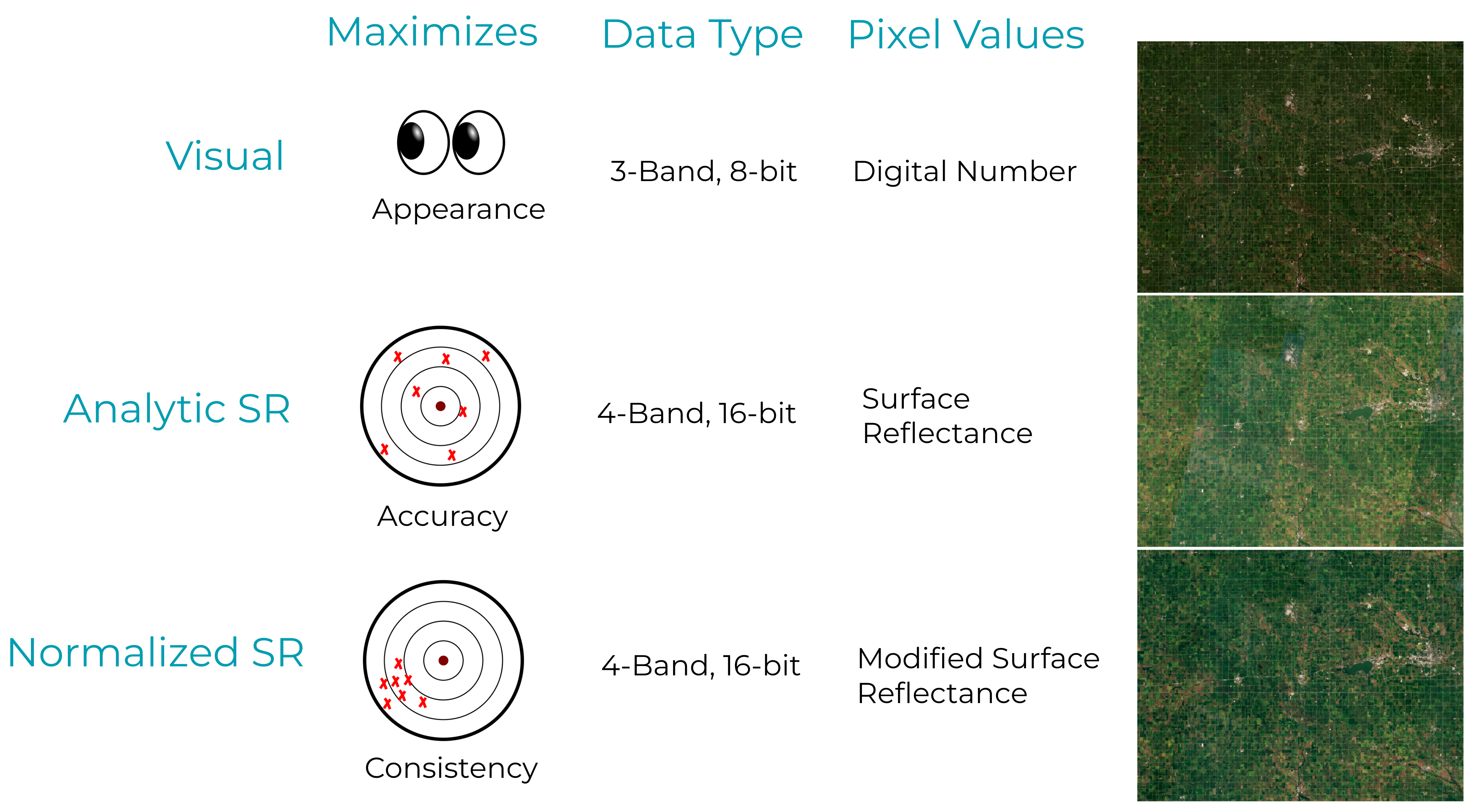
What are PlanetScope Basemaps?
Planet Basemaps are analysis-ready data products created by mosaicking the best PlanetScope imagery. Planet offers a range of basemap products, including Visual Basemaps (Visual), Analytic Surface Reflectance Basemaps (Analytic SR), and Normalized Surface Reflectance Basemaps (Normalized SR), all designed for visual and/or analytical use. These basemaps are categorized based on their use case and are available as Global Basemaps and Select Basemaps, the latter encompassing both visual and surface reflectance options.
Planet Basemaps are generated by querying PlanetScope scenes that overlap a specific area of interest within a designated time frame. These scenes are then ranked based on quality metrics metadata, such as the presence of clouds and haze, with the highest quality scenes placed at the top. Using a "best-on-top" algorithm, the highest quality scenes are efficiently composited to create the final basemap. A quick guide is provided on this flowchart to help determine which basemap to choose based on various use case examples.
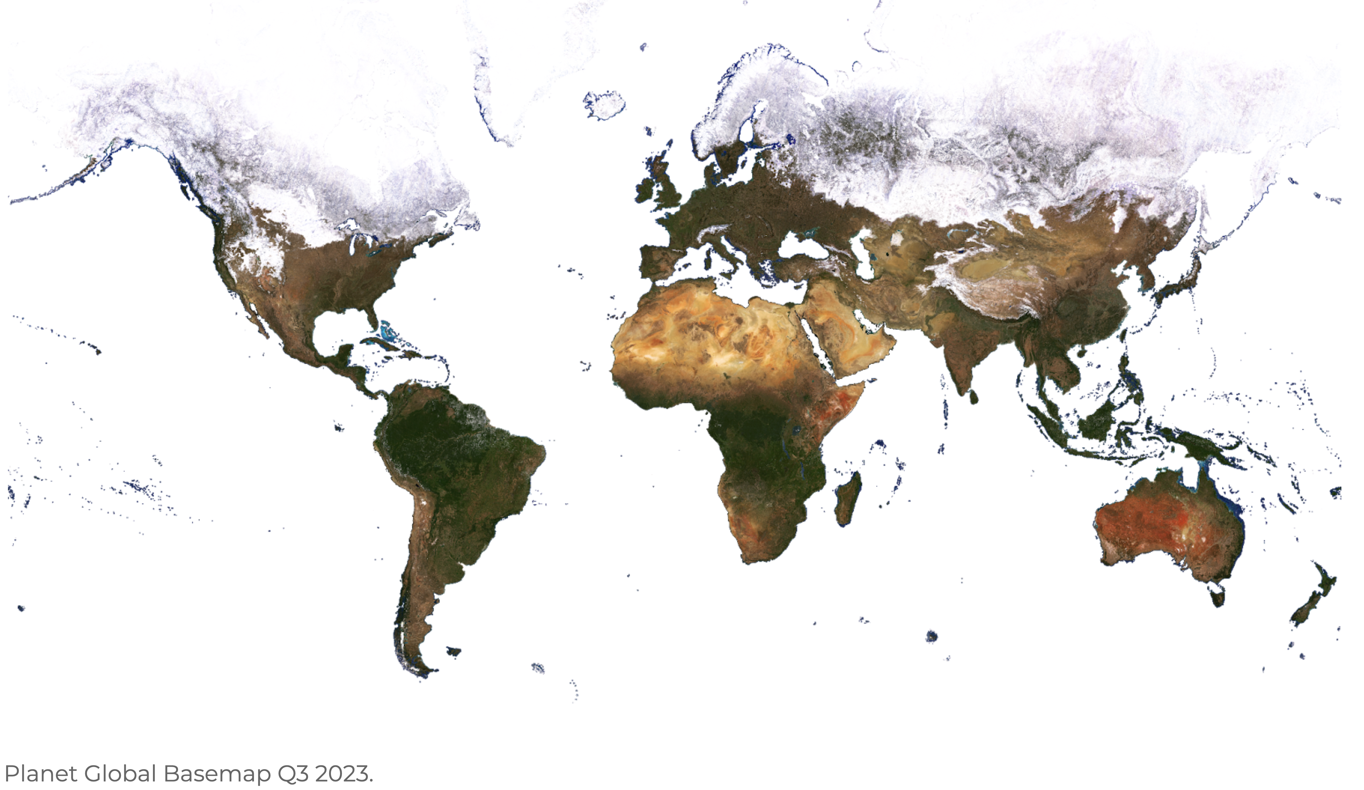
Global Basemaps
Global Basemaps are generated between 74° North and 60° South to minimize distortion at the poles, using PlanetScope and/or RapidEye imagery. These basemaps are color-corrected and designed for both human viewing and computer vision analytics. The Global Basemap product is the Q3 Quarterly Select Visual Basemap, with distinct pricing due to its global nature. While all basemap products can be generated globally, this version is specifically created at a set interval to ensure a consistent global visual product. The Global Basemap is typically utilized in background GIS applications, or as a visual background.
Select Basemaps
Select Basemaps are generated at weekly, monthly, and quarterly intervals, tailored to customer-specified areas of interest. These basemaps are categorized into two product types: Visual and Surface Reflectance.
Select Basemaps Visual
Visual Basemaps are optimized to minimize the effects of cloud cover, haze, and topographic variations. These basemaps are color-corrected and designed for human viewing and computer vision analytics, enabling users to monitor landscape and infrastructure changes over time and space.
| Source Imagery | Download Bands | Streaming Bands | Monitoring Frequency | Zoom Level | Color Target |
|---|---|---|---|---|---|
| PlanetScope and/or RapidEye* Visual Product |
RGB | RGB | Weekly Monthly Quarterly |
15 | MODIS |
*RapidEye Imagery is used on Global Basemaps for dates prior to February, 2020.
Select Basemaps - Surface Reflectance
Select Surface Reflectance Basemaps are created using the PlanetScope Surface Reflectance imagery asset type (analytic_sr). These basemaps are optimized to reduce the variability due to atmospheric effects, enabling users to perform spectral, quantitative, and time series analyses. Surface Reflectance Basemaps include both Analytic Surface Reflectance (Analytic SR) and Normalized Surface Reflectance (Normalized SR).
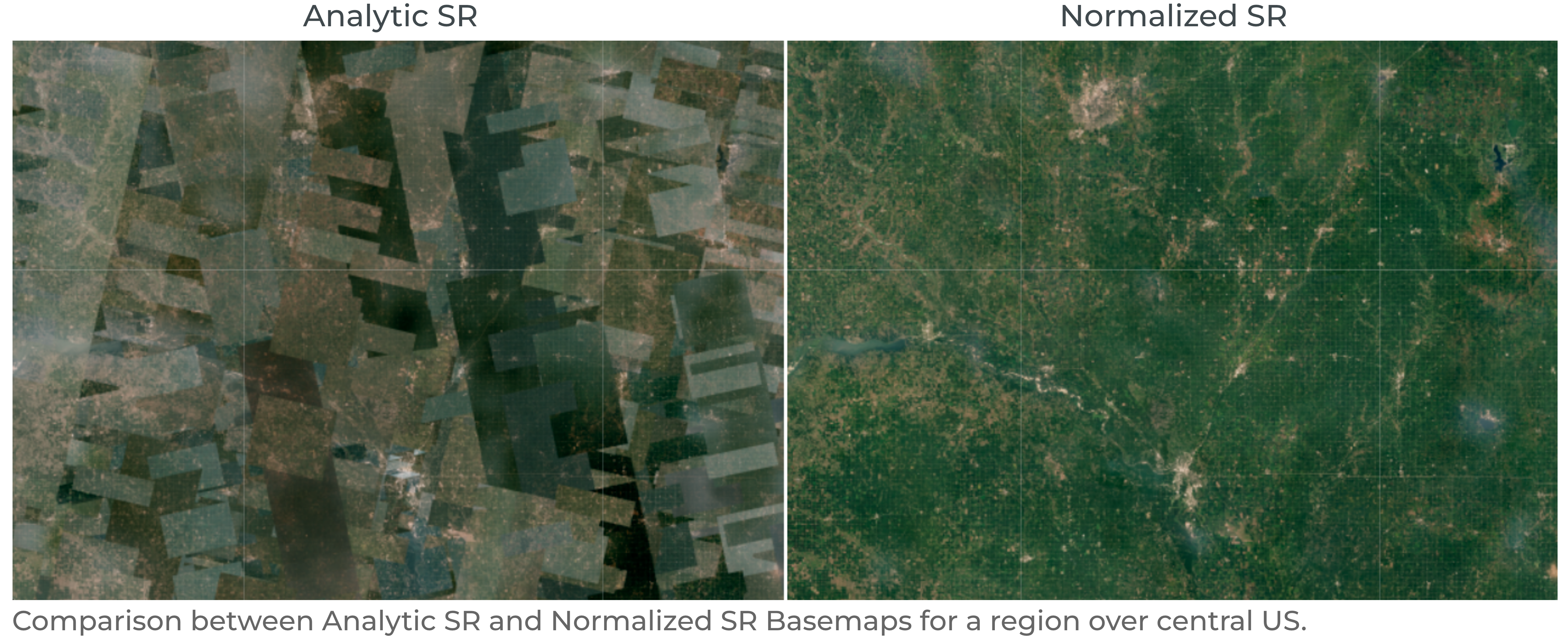
Analytic SR Basemaps preserve the calculated surface reflectance pixel values without any color balancing or adjustments. As a result, these basemaps may exhibit visible seamlines due to the combination of scenes captured by different sensors, on various dates, and at different times of day. They are ideal for situations where precise radiometric accuracy is more important than consistency. These basemaps are particularly effective for shorter time intervals (e.g. weekly) updates, and are well-suited for applications requiring recent imagery or change detection, such as crop health monitoring, and wildfire burn assessment.
Normalized SR Basemaps undergo additional processing steps to improve spatial and temporal consistency, making them less likely to have seamlines. The normalization process involves matching the basemaps to a common reference target. The targets are multi-year monthly composite mosaics, derived using Sentinel-2 imagery, with the goal of enhancing the spatial and temporal consistency of the basemaps, enabling time-series analyses. Nonetheless, the normalization process can result in less accurate absolute spectral values. These basemaps are ideal for use cases where spatial consistency is prioritized or for generating training data for machine learning algorithms. They are particularly suited for longer time periods (e.g., monthly, quarterly) where multiple scenes are mosaicked together, and additional image processing is beneficial. Applications include land cover classification, forest disease monitoring, and flood risk analysis.
Select Basemaps - Surface Reflectance Source Imagery
| Source Imagery | Download Bands | Streaming Bands | Monitoring Frequency | Zoom Level | Color Target | ||
|---|---|---|---|---|---|---|---|
| PlanetScope Surface Reflectance |
BGRN | RGB, CIR | Weekly Monthly Quarterly |
15 | Sentinel-2 | ||
| PlanetScope 8-Band Surface Reflectance | CB,B,G,GII,Y,R, RE,NIR |
RGB, CIR | Weekly Monthly Quarterly |
15 | Sentinel-2 |
Select Basemaps - Surface Reflectance Product Details
| Type | Prioritizes | Data | Pixel Values | Normalization |
|---|---|---|---|---|
| Analytic SR | Spatial accuracy; precise spectral responses | 4-band, 16-bit | Surface Reflectance | None |
| 8-Band Analytic SR | Spatial accuracy; precise spectral responses | 8-Band, 16-bit | Surface Reflectance | None |
| Normalized SR | Spatial & temporal consistency; training data | 4-band, 16-bit | Modified Surface Reflectance | Sentinel-2 |
| 8-Band Normalized SR | Spatial & temporal consistency; training data | 8-Band, 16-bit | Modified Surface Reflectance | Sentinel-2 |
Select Basemaps - Availability
| Type | Available After | UDM2 | Pixel Provenance |
|---|---|---|---|
| Visual | January 2016 | Mixed | Yes |
| Analytic SR* | May 2016 | After August 2018 | Yes |
| 8-Band Analytic SR | August 2020 | Yes | Yes |
| Normalized SR | May 2016 | After August 2018 | Yes |
| 8-Band Normalized SR | August 2020 | Yes | Yes |
*4-Band Analytic SR Basemaps are only available for dates prior to August 2020.
Product Specifications
Basemap Quads
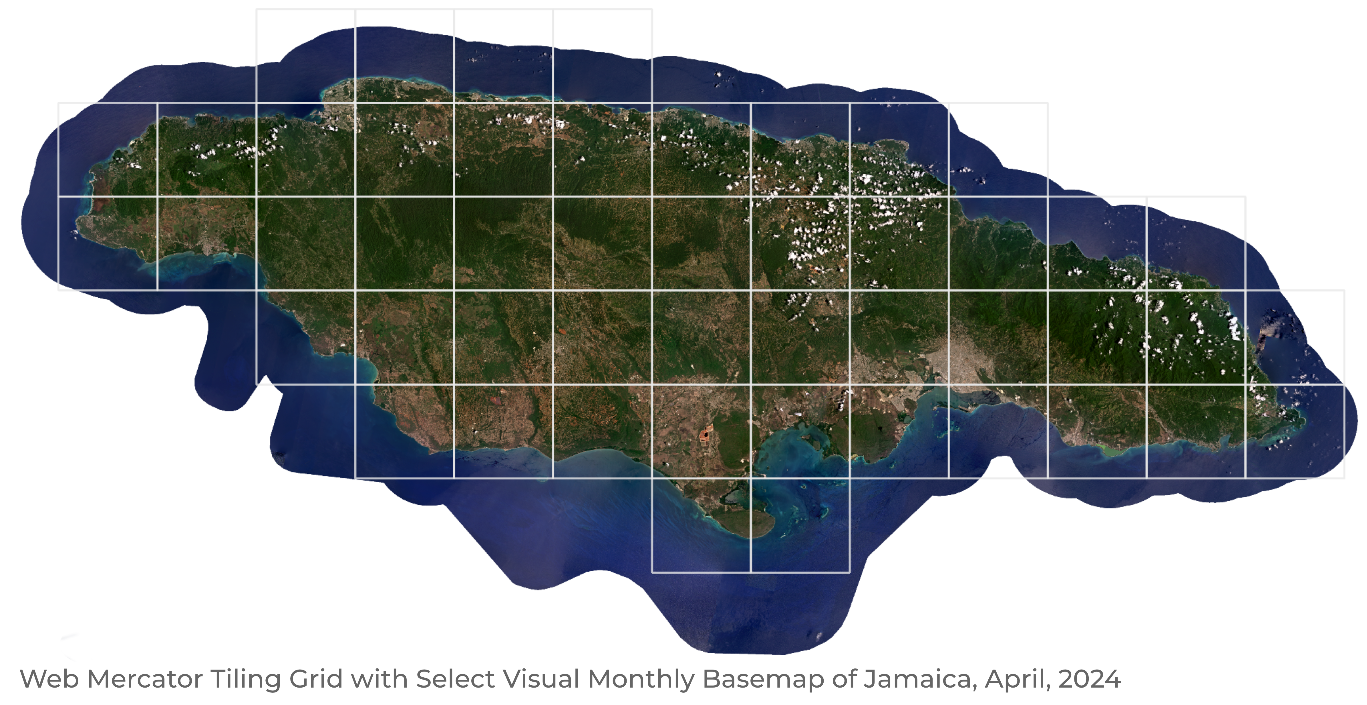
Planet Basemaps use the Web Mercator projection, the standard for web mapping applications, due to its efficiency in handling large geospatial datasets. This projection supports a tile-based system, dividing the world into uniform square tiles at multiple zoom levels. This allows for pre-rendered and cached tiles for fast map loading and smooth user interactions in GIS applications. Planet Basemaps are distributed as a grid of GeoTIFF files, which are called quads—the size of each quad is 4096 x 4096 pixels.
| Attribute | Description |
|---|---|
| Imagery | PlanetScope and RapidEye (Visual) PlanetScope (Surface Reflectance) |
| Pixel Size* | 4.77 m at the Equator for zoom level 15 (PlanetScope and RapidEye) |
| Image Bit Depth | 8-bit (Visual) 16-bit (Surface Reflectance) |
| Bands | Red, Green, Blue, Alpha (Visual) Blue, Green, Red, NIR, Alpha (Surface Reflectance) Coastal Blue, Blue, Green I, Green II, Yellow, Red, Red Edge, NIR, Alpha (8 band) |
| Projection | WGS84 Web Mercator (EPSG:3857) |
| Size | 4096 x 4096 pixels |
| Processing | Orthorectification Atmospheric correction (Surface Reflectance only) May be radiometrically balanced Seamlines may be minimized with tonal balancing |
*The pixel size in meters can be estimated as follows: 4.77 * cos(latitude) m (4.77 m at the Equator) for zoom level 15 (PlanetScope and RapidEye).
Product Naming
The name of each basemap quad represents the x and y position of the quad within the two dimensional grid which makes up the basemap. For example, {X}-{Y}, where X and Y are the x and y position of the quad in the grid.
Example:
439-1220
Upon download, the name of the downloaded quad also contains the Zoom Level.
Example:
L15-0439E-1220N.tif
Publication
Planet aims to publish all standard Select Basemaps 7 days after the end of the acquisition period. However, there may be instances where publishing may take longer. Publishing times for custom basemaps are determined on a case-by-case basis.
Cadence
Basemaps are generated at a specified cadence based on the first_acquired and last_acquired UTC timestamps for underlying source imagery.
| Cadence | Start (first_acquired) |
End (last_acquired) |
|---|---|---|
| Weekly | Mondays at 00:00:00 UTC | Sundays at 23:59:59 UTC |
| Monthly | The first day of each month at 00:00:00 UTC | The last day of each month at 23:59:59 UTC |
| Quarterly | January 1st, April 1st, July 1st, and October 1st at 00:00:00 UTC | March 31st, June 30th, September 30th, and December 31st at 23:59:59 UTC |
Planet Basemaps Delivery
Basemaps can be downloaded or streamed through multiple methods. Below are some of the available options.
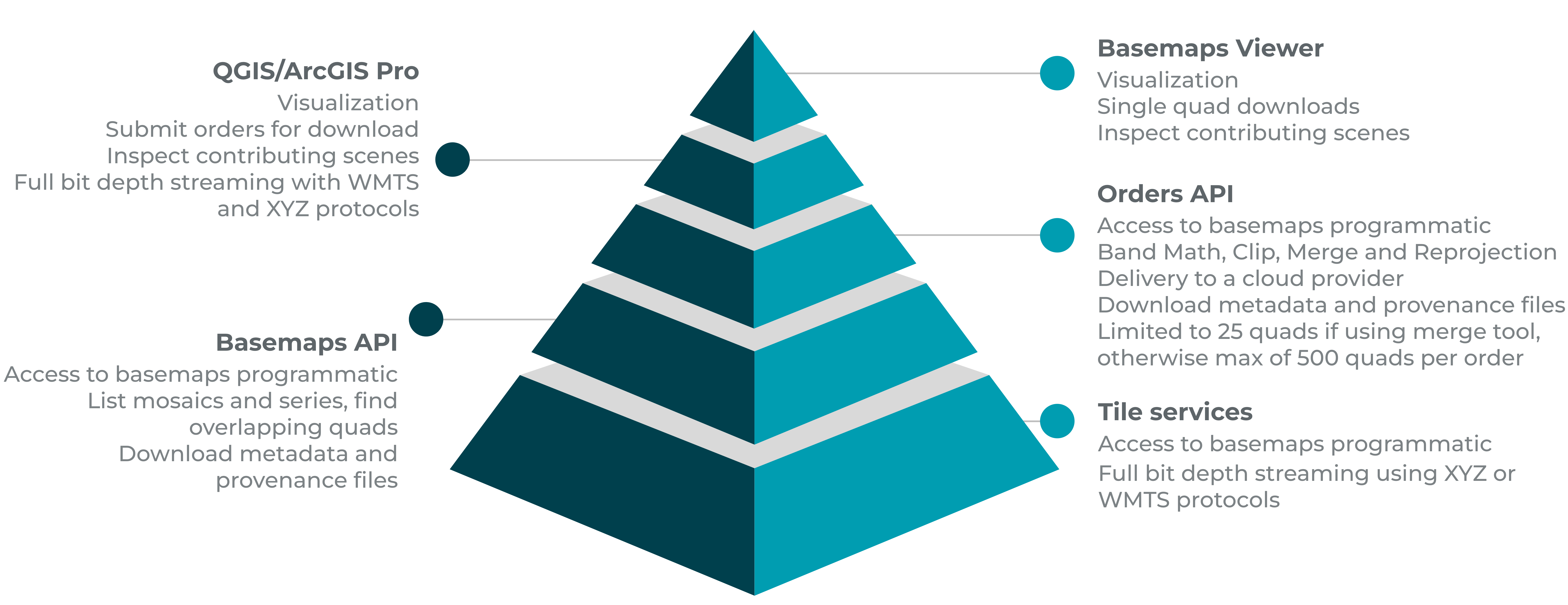
Basemaps Viewer
Basemaps Viewer is an online tool used to view and download basemaps quads. A complete tutorial on how to use Basemaps Viewer is available on this introductory course from Planet University.
QGIS/ArcGIS Pro Plugins
Basemaps can be downloaded or streamed through Planet’s QGIS or ArcGIS Pro plugins. These plugins enable users to search for basemaps within the catalog and offer multiple filtering options, such as filtering by area of interest or by different types of basemaps.
Orders API
Basemaps can also be accessed through the Orders API, which allows users to reproject the data to a coordinate system other than Web Mercator, clip basemaps to a specified extent, merge multiple quads, perform band math calculations, and deliver the data to a cloud service provider. However, there are limitations to consider. Users can merge and download up to 25 quads at once. If the merge tool is not used, the limit is 500 quads per order, meaning the provided geometry must encompass fewer than 500 quads. For downloading areas larger than 500 quads, it is recommended to use the Basemaps API.
For more detailed information, follow the online tutorial on how to use the Orders API to download basemaps. Additionally, an online guide is available here.
Basemaps API
The Basemaps API is recommended for users seeking endpoints for scalable workflows, direct access to Cloud Optimized GeoTIFF links, and the ability to stream basemaps into web applications. Often, users combine the capabilities of both APIs (Orders and Basemaps) when writing their own libraries to access basemaps. The detailed API reference can be found here.
Some use cases of the Basemaps API are:
- Find the quads that intersect an Area of Interest and download those quads.
- Get the list of items that contribute to the particular quad.
- Stream into web applications using the XYZ and WMTS protocols.
- Get a list of series and mosaics available for a user.
Quad Packaging
Basemaps quads can be downloaded through the Basemaps API and Orders API along with their associated metadata (JSON), UDM2 assets, and pixel provenance raster and vector files, which trace all scenes used when producing the quads. The table below shows the list of files returned when downloading a single quad, and their associated files, for a Normalized SR Basemap.
| File name | Size |
|---|---|
| 484-1310_quad.tif | 117 MB |
| 484-1310_provenance_raster.tif | 236 KB |
| 484-1310_ortho_udm2.tif | 1.2 MB |
| 484-1310_provenance_vector.zip | 22 KB |
| L15-0484E-1310N.dbf | 788 B |
| L15-0484E-1310N.prj | 425 B |
| L15-0484E-1310N.shp | 66 KB |
| L15-0484E-1310N.shx | 124 B |
We are continually working to improve our technical documentation and support. Please help by sharing your experience with us.