June 27, 2023
Decommissioned SkySat Planned Re-entry Completed 🙌🏻
On June 26, the Planet Mission Operations team managed the final operations and reentry of a decommissioned SkySat satellite. As a part of our commitment to responsible space use, bringing this SkySat down from space ensures that it does not pose a risk to other spacecraft or further contribute to space debris.
As a reminder, this is a planned re-entry and does not have any notable impact on our high-resolution fleet’s capacity or customers’ tasking abilities, because Planet’s Agile Aerospace approach optimizes capabilities around a constellation of satellites, and the team has continued to innovate and improve our tasking capabilities across the program. We are able to apply learnings from the SkySat fleet as we look forward to launching the upcoming in-space tech demo of high-resolution Pelicans in the near future.
OGC Made Easy: Tiling Spec
By: Tim Schaub on May 12 2023
Looking for help getting started with the Open Geospatial Consortium (OGC) API Tiles specification? This primer can get you going.
OGC Made Easy: Tiles
The Open Geospatial Consortium (or OGC) publishes standards related to geospatial information services and formats. The organization recently published “OGC API - Tiles - Part 1: Core” – a specification aimed at web map tile services. The standard weighs in at 137 pages and depends on another 273 page standard, so if you are new to OGC specifications, getting started can be intimidating. The goal of this post is to provide a quickstart for tiled map providers who might want to implement the standard but are struggling to know where to begin.
What’s in a name?
The “OGC API - Tiles - Part 1: Core” specification name is quite a mouthful. The rest of this post will use "OGC Tiles" as a shorthand, but it is worth picking apart the name first.
The previous generation of OGC standards had titles like "Web Map Service" (WMS), "Web Feature Service" (WFS), and "Web Coverage Service" (WCS). These were affectionately referred to as the WxS standards. The "OGC API" prefix in this new specification’s name refers to the new generation of standards designed to work in harmony with existing web standards and best practices – so things like content negotiation and HTTP status codes aren’t redefined by the standards themselves.
The "Tiles" part of the name is what this standard is really about. Before the Google Maps era, maps on web pages were often provided by services that would generate map images of arbitrary places on demand. It is generally faster and more efficient to render map images ahead of time and to cut these images up into regular grids of tiles. The OGC Tiles specification describes how mapping clients (like web pages) can get information about tilesets and how to request the tiled data itself.
The "Part 1: Core" suffix in the standard’s name implies that additional parts will be published in the future describing functionality beyond the core. The core concerns itself with how to provide metadata about a tileset, how to describe the tiling scheme, and how to relate a tileset to a geospatial data collection that might have other representations. The core also discusses how a tileset with a temporal dimension can be handled.
Prior art
For the last 18 years since the launch of Google Maps, people who develop mapping applications on the web have been consolidating on a common scheme for serving tiled map data. The tiles in this scheme fit into a conceptual pyramid where each tile can be identified by three parameters: zoom level (Z), column (X), and row (Y). This has become known as the XYZ tiling scheme.
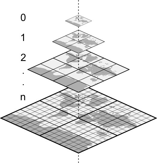
In an XYZ tileset, the 0/0/0 tile at the top usually covers the whole world, and each level below contains four tiles for every one tile above. Most XYZ tilesets use the same Web Mercator projection as Google Maps. XYZ tiles are usually available with a URL that looks like this: https://example.com/tiles/{z}/{x}/{y}.png. In this URL template, {z} is a placeholder for the zoom level, {x} for the column number, and {y} for the row number. The available zoom, column, and row values generally start with zero. The zoom level may extend to something in the 20s for "street level" data.
Of course all of these things (extent, projection, URL template, maximum level) may vary from tileset to tileset. The Mapbox TileJSON specification formalizes how some of this variety can be described in a simple JSON document. One notable constraint of TileJSON is that tilesets must use the Web Mercator projection popularized by Google Maps.
Conformance
The OGC Tiles specification builds on what people have been doing for years with XYZ tilesets and goes beyond what is possible to describe with TileJSON. The standard is organized into conformance classes that build on one another to handle increasingly complex use cases.
The good news is that if you have an existing XYZ tileset, you are (most likely) already OGC Tiles compliant! The Core Conformance Class boils down to three unconditional requirements:
- Tiles must be available using a URL built from a template like
https://example.com/tiles/{z}/{x}/{y}.png(see Requirement 1 for more detail). - Successful responses must have a
200status code (see Requirement 5 for more detail). - Responses for tiles that do not exist must have a
400or404status code (see Requirement 6 for more detail).
The Core Conformance Class in OGC Tiles has additional requirements that only kick in under certain conditions. For example, if you also conform to the Core Conformance Class from the separate “OGC API - Common - Part 1: Core” standard, then requirements 2, 3, and 4 in the Tiles standard say that you have to use {tileMatrix} instead of {z}, {tileRow} instead of {y}, and {tileCol} instead of {x} in your tile URL template (but the core doesn’t have any requirements about how this tile URL template is advertised).
If you have an XYZ tileset and you pass the list of requirements above, then you can say that you implement the Core Conformance Class from the "OGC API - Tiles - Part 1: Core" specification. The OGC Common standard describes a formal way to advertise which conformance classes are implemented. For example, if you conform with the Core Tile requirements and the Core Common requirements, you would advertise this with a document like this:
{
  "conformsTo": [
    "http://www.opengis.net/spec/ogcapi-common-1/1.0/conf/core",
    "http://www.opengis.net/spec/ogcapi-tiles-1/1.0/conf/core"
  ]
}
The Core Conformance Class from the "OGC API - Common - Part 1: Core" standard requires that a conformance document like the one above is available at a /conformance path relative to the root of your service. So a service at https://example.com/ would make the conformance document available at https://example.com/conformance.
Beyond the core
The Core Conformance Class in OGC Tiles adds a bit of formality to what people have already been doing with XYZ tilesets. If you want to provide additional metadata about your tilesets, you can make use of the conformance classes beyond Core. The next set of requirements to consider are part of the Tileset Conformance Class. You might choose to implement these requirements if your tileset doesn’t cover the whole world, if you want to let clients know about a limited set of available zoom levels, or if you use an alternative projection, for example.
The Tileset Conformance Class depends on a separate standard, “OGC Two Dimensional Tile Matrix Set and Tile Set Metadata” (referred to as TMS below), to define the structure of the tileset metadata. Examples are included below, but if all you want is the JSON Schema for tileset metadata, you can find that here: https://schemas.opengis.net/tms/2.0/json/tileSet.json.
Here is an example tileset metadata document that describes the XYZ OpenStreetMap tiles:
{
  "title": "OpenStreetMap",
  "dataType": "map",
  "crs": "http://www.opengis.net/def/crs/EPSG/0/3857",
  "tileMatrixSetURI": "http://www.opengis.net/def/tilematrixset/OGC/1.0/WebMercatorQuad",
  "links": [
    {
      "title": "Tile URL Template",
      "href": "https://tile.openstreetmap.org/{tileMatrix}/{tileCol}/{tileRow}.png",
      "rel": "item",
      "type": "image/png",
      "templated": true
    },
    {
      "title": "Tiling Scheme",
      "href": "https://ogc-tiles.xyz/tileMatrixSets/WebMercatorQuad",
      "rel": "http://www.opengis.net/def/rel/ogc/1.0/tiling-scheme",
      "type": "application/json"
    }
  ]
}
The optional title provides users with an easy way to identify the tileset. You can also provide an optional description with more information. The dataType is a required property. Values can be map (for rendered raster data), vector (for vector tile data), or coverage (for raw raster data). The crs is an identifier (specifically a URI) that indicates which coordinate reference system is used. The tileMatrixSetURI is an identifier for the tiling scheme used. The coordinate reference system and tiling scheme shown corresponds to the setup popularized by Google Maps (zoom level zero has one 256 x 256 pixel tile covering the world in Web Mercator; every level below has four tiles for each tile above). The links property includes a link to the tiling scheme definition (also referred to as tile matrix set). As an alternative to linking to a separate document with the tiling scheme definition, the definition can be included in the tileset metadata using a tileMatrixSet property (this is Requirement 17 of the TMS standard). Finally, and most importantly, the links list includes the tile URL template for requesting individual tiles.
One of the most useful reasons to implement the requirements of the Tileset Conformance Class is to let clients know that a tileset is not available for the whole world. The boundingBox property of the tileset metadata serves this purpose, and including it enables a client to automatically zoom to exactly where there are tiles available. Here is an example bounding box member that indicates that tiles are only available north of the equator and west of the prime meridian (see the tileset-bbox.json for a complete example that includes the whole world as a bounding box):
"boundingBox": {
  "crs": "http://www.opengis.net/def/crs/OGC/1.3/CRS84",
  "lowerLeft": [-180, 0],
  "upperRight": [0, 90]
}
The tileset metadata can also include a tileMatrixSetLimits property. It is recommended that tilesets with limited extent (compared to the extent of the tiling scheme) use this property in addition to the boundingBox to describe those limits.
The tileMatrixSetLimits property is also useful to describe a limited set of zoom levels. For example, if only zoom levels 2 and 3 were available for a particular tileset, the limits could be described with this metadata (see the tileset-limits.json for a complete example):
"tileMatrixSetLimits": [
  {
    "tileMatrix": "2",
    "minTileRow": 0,
    "maxTileRow": 1,
    "minTileCol": 0,
    "maxTileCol": 1
  },
  {
    "tileMatrix": "3",
    "minTileRow": 0,
    "maxTileRow": 3,
    "minTileCol": 0,
    "maxTileCol": 3
  }
]
The above tileMatrixSetLimits only limit the available zoom levels or tile matrix levels. To limit the available extent as well, adjust the minimum and maximum column and row values. The JSON schema for this property is available here: https://schemas.opengis.net/tms/2.0/json/tileMatrixLimits.json.
Next steps
The OGC Tiles standard describes additional sets of requirements beyond the Core and Tileset Conformance Classes. For example, the Tileset List Conformance Class includes requirements for describing a list of tilesets with a subset of the metadata required for an individual tileset (see Requirement 9 and 10). In addition, the OGC Common standard includes requirements that can be useful if your tilesets are related to other geospatial data collections. The OGC API family of standards leverages OpenAPI and JSON Schema for describing services. If your tileset is provided by a service that already makes use of OpenAPI, it can be useful to implement the OpenAPI Conformance Class of the OGC Common standard.
Because these requirements are spread across multiple specifications with slightly different conventions and vocabulary, it can be a challenge to get started if you want to implement a compliant tile service. We put together a go-ogc library and a xyz2ogc utility to help bootstrap the process. You can use the xyz2ogc generate command to produce metadata documents describing an existing XYZ tileset that satisfies the requirements of the conformance classes discussed above. See https://ogc-tiles.xyz/ for a complete set of metadata documents representing some common XYZ tilesets.
Be sure to share your experiences using OGC Tiles with us at https://community.planet.com/developers-55. Follow us on Twitter @PlanetDevs. Sign up for Wavelengths, the Planet Developer Relations newsletter, to learn more about our workflows and get announcements about what is new.
June 22, 2022
Improvements 🙌🏻
Users can now get tile usage using the Reports API.
Tile usage was available through the reporting user interface. We have now integrated tile usage into the Reports API. Users can go to the new endpoint and get their tile view usage with the parameters they enter.
For more information, checkout getTilesUsageReport in the Reports API reference.