Overview
Planet’s Basemaps are composed of Planet’s “best available” PlanetScope or SkySat imagery scenes mosaiced together over a specific time of interest to provide a near-cloud-free view of an area of interest.
To learn more about the imagery specifications of Planet Basemap products, please see Planet's Basemaps Product Spec.
Search for Basemaps
Basemaps in the Planet QGIS Plugin are organized into three categories: One-off, Series & All.
- The One-off filter catalogs Basemaps that don’t belong to a time-series, i.e., they were purchased and produced for a single AOI/TOI.
- The Series filter catalogs Basemaps that belong to a time-series. Planet produces time-series Basemaps for many intervals, the most common are “monthly” and “weekly” Basemaps.
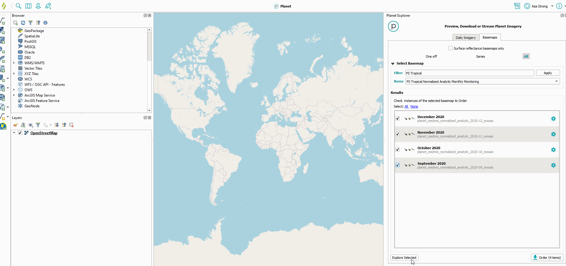
- The All filter is a catch-all for One Off and Series Basemaps. The All filter also has a text filter that allows you to filter Basemaps using keywords (e.g., “PS Tropical”).
Additionally, all Basemaps can be filtered by “Surface Reflectance only,” which if applied, will limit results only to Basemaps that have been atmospherically corrected for surface reflectance values and include additional spectral information like near-infrared. Learn more about SR correction on PlanetScope data here.
Stream Planet Basemaps
Planet QGIS Plugin users can stream Basemaps into QGIS as a single Basemap or as part of a time-series.
To stream a Basemap as a time-series, select each Basemap instance from the Basemaps search results panel, then select “Explore Selected”.
This will create a single “layer” in your QGIS table of contents, which will include a time-slider that allows you to animate through the time-series.
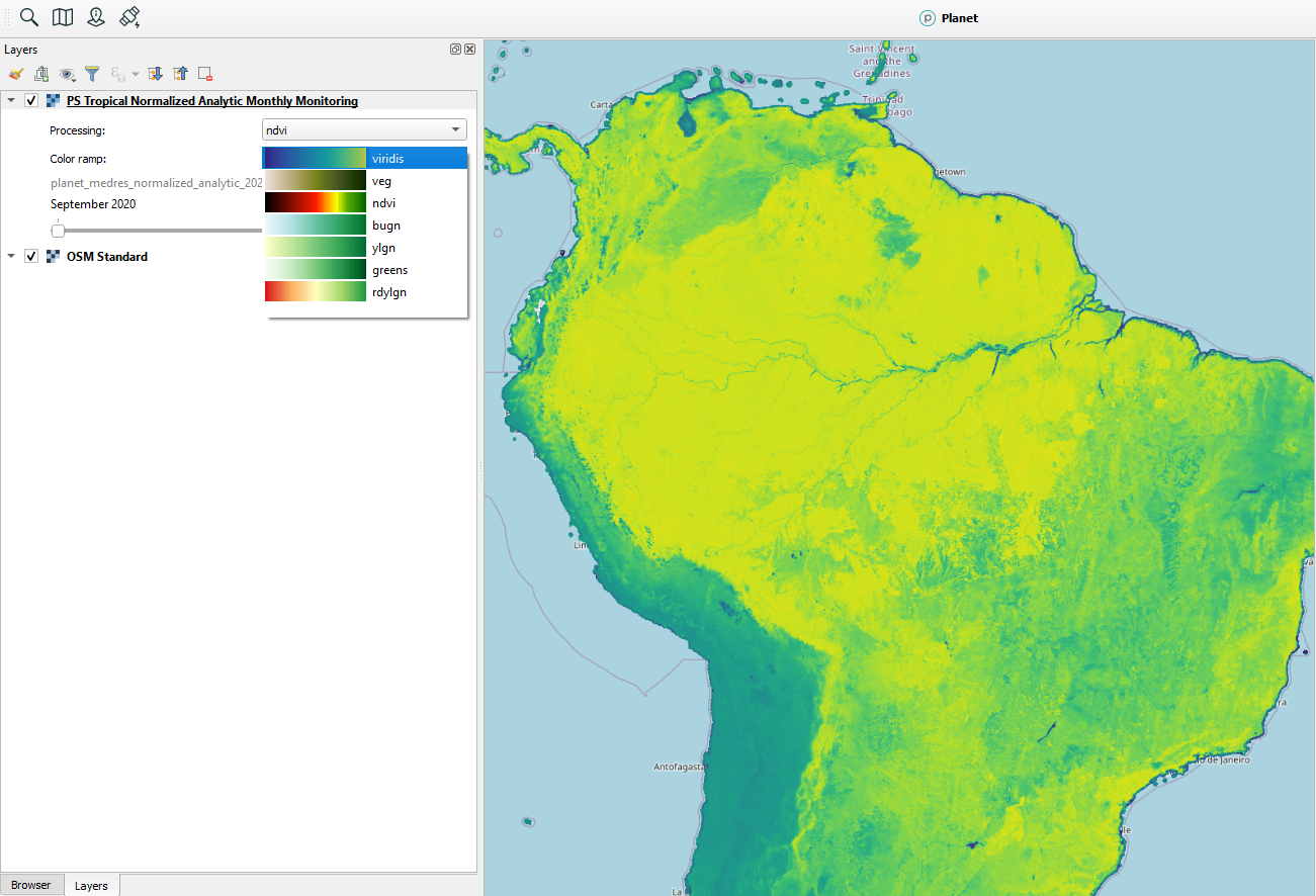
If the Basemap you are streaming is a surface reflectance Basemap, you will have a processing option drop-down menu below the Basemap layer, which enables you to stream the Basemap in false color like color infrared or as a spectral index visualization like NDVI. There are also a number of select color ramp options to complete your visualization.
Identify Basemap Source Scene
Some Planet Basemap users may want to be able to identify the contributing “source” scene for a specific location in a Planet Basemap so that they can view metadata about the pixels such as their specific collection date.
The Planet Inspector panel in the Planet QGIS Plugin allows users to do just that: select a location on a Planet Basemap and identify the source scene for that location.
To use the Planet Inspector tool, first open the Planet Basemap that you’d like to inspect and make sure you have the Basemap selected in your QGIS Layers panel. If you have a Basemap Series added to your QGIS Map, make sure that the series is on the specific temporal instance that you’d like to inspect. Zoom to the area that you’d like to inspect for more detail.
Then select the Planet Inspector icon from the Planet QGIS Plugin panel, and click the “wand” icon on the panel that appears. This will enable your cursor for inspection. To use, simply click a location on the selected Basemap that you’d like to inspect.
The tool will return the Planet imagery scene that contributed to that specific location in the Basemap. By default you should be able to view the specific date and UTC time that the image was collected. If your account has permissions to access that source imagery scene, you can select the gear icon next to the image in the Planet Inspector panel and click “Open in Explorer”. This will open the image into the Planet QGIS Search Panel where you can further explore its metadata, stream the preview layer or download the image.
Order & Download Basemaps
Planet Basemaps are distributed as a grid of GeoTIFF files which are called “Basemap quads” or simply “quads”.
If your Planet Basemaps subscription includes download quota, you will be able to use the Planet QGIS Plugin to download a subset of or your entire Basemap’s quads.
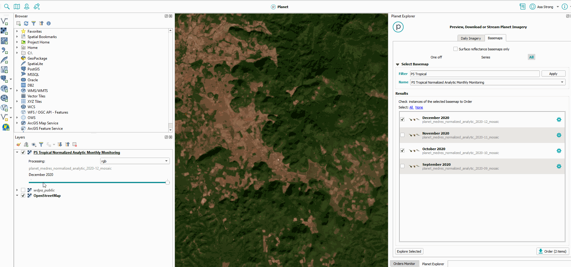
To download a Baseamp, first select the Basemap instance or instances (you can select more than one Basemap of the same time series) you’d like to download from the Basemap search results, then select “Order” from the bottom-right of the Basemaps Panel.
The Order Basemap Panel presents user’s with three options: * Download Complete Basemap(s) * Download Specific AOI from Basemap(s) * Create streaming connection(s)
Option 1: Download Complete Basemap(s)
This should only be used for Basemaps of a size that can be managed on a single desktop computer. Generally, surface reflectance Basemaps are ~120MB per visual ~35MB per quad.
If you select to download a Basemap with more than 500 quads, you will be prompted with a warning message about the size. Continue if it is an acceptable download size.
Option 2. Download Specific AOI from Basemap(s)
To download a subset of your Basemap(s) based on an area of interest, select option 2. Then use the draw tools to define your area of interest. Once your AOI is set, select “Find Quads”. This will query Planet’s Basemaps API to find all the quads across the Basemap instances you selected for download.
Select the quads you’d like to download and then select “Next”. Provide a name for your download. Selecting the option to “create virtual layer” will generate a mosaiced .vrt layer for your Basemap quads.
To open your download, navigate to the Orders Panel and select “download” option next to the name of your Basemap Quad order.
![]()
Option 3. Create Streaming Connection(s)
You can also establish a XYZ tile connection to your QGIS catalog for your Planet Basemap(s). Open your QGIS “Browser” panel to locate your “XYZ Tile” connections. XYZ tiles are a protocol that describes how a mapping client (like QGIS) can access tiled imagery. E.g., OpenStreetMap is usually available as a XYZ tile connection by default in most versions of QGIS. You can learn more about Planet’s XYZ tile services here.
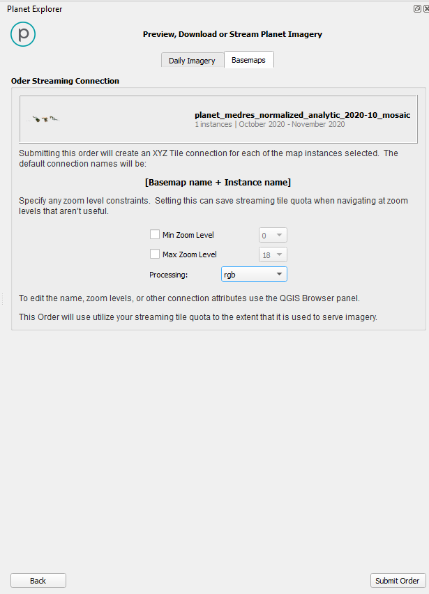
When establishing a streaming connection, you will have options to specify a processing option, which will apply a spectral index or false color visualization to your SR Basemap. Setting a processing option will apply that visualization as a default for your streaming connection, however, you will still be able to change to a different processing option when you add the streaming connection to your map (and you remain logged in the Planet Plugin).
You can also specify a Min/Max zoom level that you’d like to set your Basemap streaming service to. Setting a min/max zoom level will restrict pixel rendering to only those zoom levels.
We are continually working to improve our technical documentation and support. Please help by sharing your experience with us.