Planet basemaps are added to ArcGIS Online (AGOL) by using either of the following Planet tile service protocols:
- WMTS
- XYZ
Complete details about each of these tile services is available in, Tile Services Overview.
Note:
For all Planet tile services, you must be authenticated for the specific requested resource. If you do not have the correct permissions, the tile request results in a 404 error. Authentication is achieved by providing a valid api_key as a query parameter in all tile requests.
WMTS Tile Service
Web Map Tile Service (WMTS) URL Structure:
https://api.planet.com/basemaps/v1/mosaics/wmts?api_key={api-key}
To add a WMTS layer to ArcGIS Online:
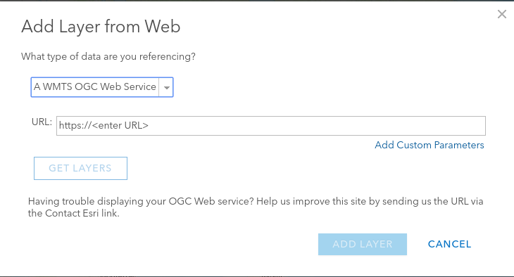
- Click Add, then select Add Layer from Web.
- From the dropdown, select WMTS OGC Web Service.
-
Input the base WMTS URL without including the
api_keyparameter:https://api.planet.com/basemaps/v1/mosaics/wmts
-
In the newly required separate section for custom parameters, add your
api_keyas follows: - Parameter Name:
api_key -
Parameter Value:
[Your API Key] -
Click on Get Layers to load the available basemaps.
- Select the desired basemap from the dropdown and click Add Layer.
XYZ Tile Service
The XYZ Tile Service URL structure for mosaics and scenes:
https://tiles{0-3}.planet.com/basemaps/v1/planet-tiles/{mosaic_name}/gmap/{level}/{col}/{row}.png?api_key={api-key}
When accessing a mosaic by using the XYZ tile service, the URL includes the mosaic name. For example:
https://tiles1.planet.com/basemaps/v1/planet-tiles/global_monthly_2019_12_mosaic/gmap/{level}/{col}/{row}.png?api_key={api-key}
XYZ Service URL structure for individual Scenes:
https://tiles{0-3}.planet.com/data/v1/{item_type}/{item_id}/{level}/{col}/{row}.png?api_key={api-key}
In this case, the URL includes both the item type and the item ID of the desired scenes. To view multiple scenes, include a comma separated list of item IDs in the URL. For example:
https://tiles1.planet.com/data/v1/PSScene3Band/20200516_171114_50_2271,20200516_171112_30_2271,20200516_171110_11_2271/{level}/{col}/{row}.png?api_key={api-key}
To add an XYZ layer to ArcGIS Online:
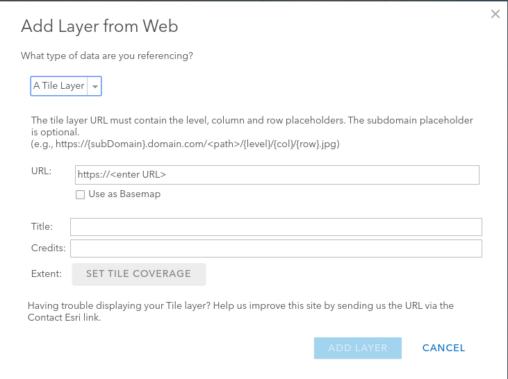
- Click Add, then select Add Layer from Web.
- From the dropdown, select Tile Layer.
- Insert URL following the structure given above, then click Add Layer.
Overzoom in ArcGIS
To zoom past the limit set by ArcGIS Online maps, add a zmax=<numeric value> parameter in the tile services URL. The zmax value provides the ability to zoom past the native resolution of Basemaps. For example:
https://api.planet.com/basemaps/v1/series/431b62a0-eaf9-45e7-acf1-d58278176d52/wmts?api_key=THEIR_KEY&zmax=3
Rate this guide: