Defining your Area of Interest (AOI)
The plugin interface has many different options for definining and customizing the AOI that you would like to use to search for imagery. Once one of the tools has been used to auto-generate the Active Coordinates, you have options to zoom to, copy or change the active coordinates to whichever AOI fits your use case the best.
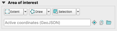
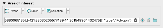
Once you have drawn, chosen an extent, or otherwise defined an AOI, the Active Coordinates (GeoJSON) field will automatically populate with the vertices of the AOI (in GeoJSON format):
Using layer or view extent
Setting an Extent - three options are available to you for setting the extent of the search area. These options allow you to define an AOI from the current map view extent, the extent of an active layer withint the map view, or the extent of all layers within the map view.
Drawing an AOI
Choosing a Draw tool - three options for shapes to draw in order to create a custom extent to use as the search area are available. You can draw a rectangle, polygon or circle to establish an AOI.
Selecting polygon(s) from your map workspace
The Selection menu allows you to select a single polygon or multiple polygons from an active vector layer in the map to create the extent for the search option.
Using GeoJSON coordinates
Once one of the three tools mentioned above is used to create, load or select
an AOI, the information about that (or those) polygons is automatically
generated in the GeoJSON Active Coordinates text box.
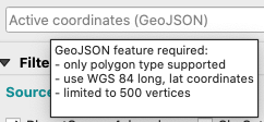
Alternatively, you may also paste a GeoJSON-formatted polygon type string directly into this box to create your AOI. If you do so, the pasted text must meet the following requirements:
* in GeoJSON format
* Is a polygon type
* in WGS 84 projection (latitude/longitude)
* 500 vertices or less
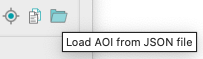
You can also directly load an AOI from a GeoJSON file that you have locally
saved, without copying and pasting the file's contents into the Active
Coordinates text box:
Viewing your AOI
After you've defined your AOI using one or more of the methods above, the
Active
Coordinates
text box will display the GeoJSON coordinates for your
AOI. From here you have the option to zoom to your AOI, copy the coordinates or
load a new AOI from a JSON file instead.
Zoom to AOI
This will zoom the map view to the extent of the AOI that is chosen:

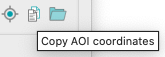
Copy AOI Coordinates
You can also copy to your clipboard the coordinates of the AOI that you chose:
Rate this guide: